PROVISIONAL DATA SUBJECT TO REVISION
Click to hidestation-specific text
Funding for this site is provided by:
 STATION.--411424077462201 CLINTON COUNTY, local well
number CN1
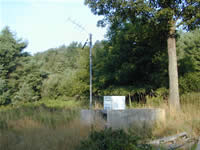
STATION.--411424077462201 CLINTON COUNTY, local well
number CN1LOCATION.--Lat 41`14'24.8", long 77`46'22.0", Hydrologic Unit 02050203, at Sproul State Forest, and at State Camp.
OWNER.--Commonwealth of Pennsylvania.
AQUIFER.--Huntley Mountain Formation, Early Mississippian-Late Devonian age.
WELL CHARACTERISTICS.--Drilled unused observation well, diameter 6 in., depth 78 ft, cased to 38 ft, open hole.
INSTRUMENTATION.--Data collection platform with 60-minute recording interval. Satellite telemetry at station.
DATUM.--Elevation of land surface is 2,045 ft above North American Vertical Datum of 1988, from Lidar. Measuring point: Top of platform, 3.20 ft above land-surface datum.
REMARKS.--Daily maximum, minimum, and mean water levels since October 1994 are available from the District Office.
PERIOD OF RECORD.--August 1950 to current year.
COOPERATION.--Funding for the operation of this station is provided by the U.S. Geological Survey.
This gage is monitored as part of the National Groundwater and Streamflow Information Program.
Summary of all available data for this site
Instantaneous-data availability statement
