PROVISIONAL DATA SUBJECT TO REVISION
Click to hidestation-specific text
Funding for this site is provided by:
 STATION.--405928077115501 UNION COUNTY, local well
number UN51
STATION.--405928077115501 UNION COUNTY, local well
number UN51LOCATION.--Lat 40`59'24.5", long 77`11'51.8", Hydrologic Unit 02050206, at Raymond B. Winter Park, and 5.5 mi east of Livonia.
OWNER.--U.S. Geological Survey.
AQUIFER.--Reedsville Formation, Late Ordovician age.
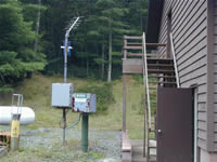
WELL CHARACTERISTICS.--Drilled observation well, diameter 6 in., depth 115 ft, cased to 91 ft, open hole.
INSTRUMENTATION.--Data collection platform with 60-minute recording interval. Satellite telemetry at station.
DATUM.--Elevation of land surface is 1,568 ft above North American Vertical Datum of 1988, from Lidar. Measuring point: Top of recorder shelf, 3.5 ft above land-surface datum.
REMARKS.--Daily maximum, minimum, and mean water levels since October 1994 are available from the District Office.
PERIOD OF RECORD.--October 1967 to current year.
COOPERATION.--Funding for the operation of this station is provided by the Pennsylvania Department of Environmental Protection and the U.S. Geological Survey.
Summary of all available data for this site
Instantaneous-data availability statement
