PROVISIONAL DATA SUBJECT TO REVISION
Click to hidestation-specific text
Funding for this site is provided by:
 STATION.--395322077365301 FRANKLIN COUNTY, local
well number FR 818
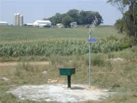
STATION.--395322077365301 FRANKLIN COUNTY, local
well number FR 818LOCATION.--Lat 39`53'21.7", long 77`36'52.6", Hydrologic Unit 02070004, near Chambersburg.
OWNER.--U.S. Geological Survey.
AQUIFER.--Stonehenge Formation, Early Ordovician age.
WELL CHARACTERISTICS.--Drilled unused observation well, diameter 6 in., depth 202 ft, cased to 37 ft, open hole.
INSTRUMENTATION.--Data collection platform with 1-minute recording interval since September 19, 2017; prior recording interval was 60-minute. Satellite telemetry at station.
DATUM.--Elevation of land surface is 772 ft above North American Vertical Datum of 1988, from Lidar. Measuring point: Top of casing, 2.90 ft above land-surface datum.
REMARKS.--Daily maximum, minimum, and mean water levels are available from the District Office.
PERIOD OF RECORD.--July 2001 to current year.
COOPERATION.--Funding for the operation of this station is provided by the Pennsylvania Department of Environmental Protection and the U.S. Geological Survey.
Summary of all available data for this site
Instantaneous-data availability statement