Funding for this site is provided by:
THIS SITE DOES NOT USE SATELLITE
TELEMETRY AND THEREFORE THE DATA WILL ONLY BE UPDATED ABOUT EVERY 8
WEEKS.
STATION.--410940074583401 PIKE COUNTY, local well
number PI 200
LOCATION.--Lat 41`09'41.1", long
74`58'34.3", Hydrologic Unit 02040104, at Pocono Mountain Lake
Estates.
OWNER.--Privately owned.
AQUIFER.--Sandstone and siltstone of Towamensing
Member of Catskill Formation of Late Devonian age.
WELL CHARACTERISTICS.--Drilled unused well, diameter 8
in., depth 799 ft, cased to 86 ft, open hole.
INSTRUMENTATION.--Data collection platform. Satellite
telemetry at station.
DATUM.--Elevation of land surface is 1,180 ft above
sea level, from Lidar. Measuring point: Top of plywood shelf, 3.3 ft
above land-surface datum. Prior to October 1983, published as 1.4 ft
above land-surface datum.
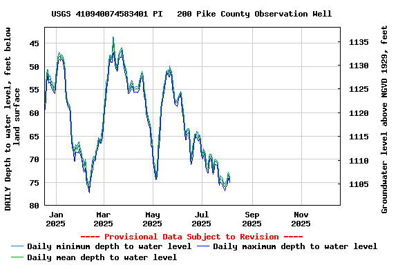
REMARKS.--Daily maximum, minimum, and mean water
levels since October 1994 are available from the District Office.
PERIOD OF RECORD.--July 1981 to current year.
COOPERATION.--Funding for the operation of this
station is provided by the Pennsylvania Department of Environmental
Protection and the U.S. Geological Survey.