
The Network Linked Data Index Geoprocessing with OGC API Processes
Update on the Network Linked Data Index processing capabilities using OGC API Process
The Network Linked Data Index (NLDI) is a search engine that indexes data to the flowpaths and/or catchments of a river network and provides discovery services based on position in that network. Like a search engine, it can cache and index new data. It also offers some convenient data services like basin boundaries and accumulated catchment characteristics.
Previous waterdata blog post (intro , new functionality and linked-data ) describe what the Network Linked Data Index (NLDI) is and what it can do in detail.
This post announces new capabilities that extend the base NLDI API with processing capabilities implemented as open-source python-based geoprocessing services that are exposed using the new OGC-API Processes specification.
NLDI API Background:
For those not familiar, a quick overview follows. The NLDI API offers an intuitive set of web resources via a linked-data endpoint. It is hosted on https://labs.waterdata.usgs.gov. ... below is used as shorthand for this base URL. For full API details, see the Swagger API documentation here.
A set of featureSources can be discovered at the linked-data root..../api/nldi/linked-data/
Each featureSource is made up of a set of features. each with its own featureID. A specific featureID can be accessed with a URL like:.../api/nldi/linked-data/{featureSource}/{featureID}
The NLDI has a navigation api based on each featureID providing upstream/downstream search and access to network-data..../api/nldi/linked-data/{featureSource}/{featureID}/navigation.../api/nldi/linked-data/{featureSource}/{featureID}/navigation/{mode}/{dataSource}
Two other capabilities stem from each featureID – one to retrieve a basin polygon upstream of the feature and one to retrieve local, total accumulated, or divergence-routed accumulated landscape characteristics..../api/nldi/linked-data/{featureSource}/{featureID}/basin.../api/nldi/linked-data/{featureSource}/{featureID}/{local|tot|div}
comid is a “special” featureSource which corresponds to identifiers for the catchment polygons and flowpath lines of the base index..../api/nldi/linked-data/comid/
The comid feautureSource offers a position endpoint allowing discovery of network identifiers for a given lon/lat location. This is a simple “point in polygon” query that returns the flowline for the catchment area the provided coordinates are in..../api/nldi/linked-data/comid/position?coords=POINT({lon} {lat})
There is also a hydrolocation endpoint that returns a linear reference to a flowline. If the provided point is within 200 meters, it is “snapped” to the flowline, otherwise the linear reference is derived using a “raindrop trace” that follows an elevation surface downstream to the nearest flowline..../api/nldi/linked-data/hydrolocation?coords=POINT({lon lat})
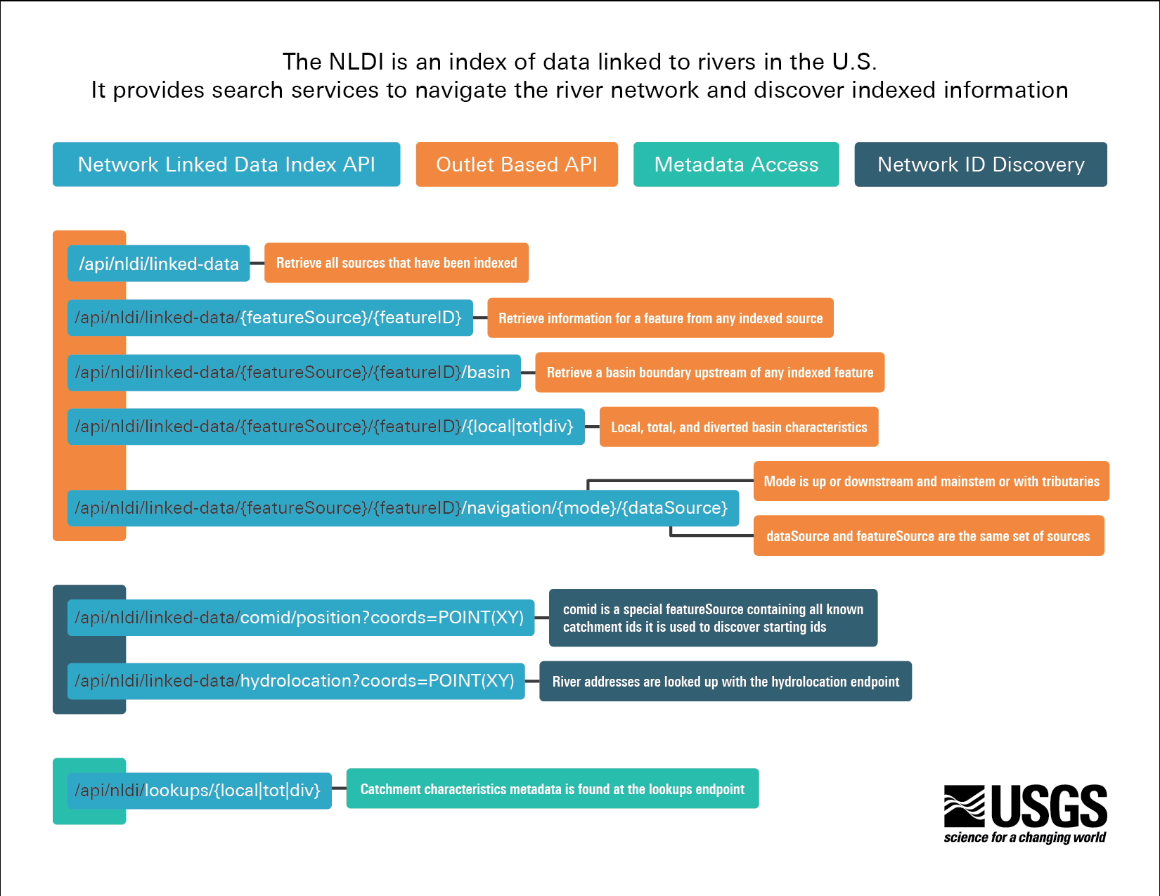
NLDI API Summary Diagram
NLDI Processing Updates:
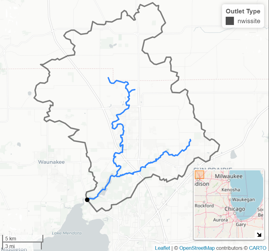
This figure shows a stream gage (black dot) at the outlet of a drainage basin. In this case, the streamgage is at a naturally occurring basin outlet in the hydrographic data used by the NLDI. But this is not always the case. Sometimes, as shown below, we need to derive a drainage basin for a point midway up a flowline river segment.
The NLDI hydrolocation and basin endpoints both rely on some custom elevation-based processing. The two processes are referred to as “raindrop trace” and “split catchment” algorithms. Two other algorithms, both to retrieve cross sections are included in the current (Spring 2022) NLDI processing services. These algorithms retrieve cross sections either at a point along a flowline from the NLDI or between two provided points (presumable spanning a river to form a cross section).
These raindrop trace an split catchment algorithms are available as stand alone python packages: nldi-xstool and nldi-flowtools as well as hosted processing services via the NLDI “pygeoapi” server. pygeoapi is a python OGC API server that the USGS waterdata teams use for a number of applications.
Both the hydrolocation and basin endpoints use the raindrop trace algorithm. It ensures that a flowline within the local catchment of a selected point is found, rather than one that is nearby but in a different catchment and the point used for basin retrieval is along a flowline rather than a small dributary implied by elevation data.
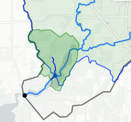
This figure shows a raindrop trace (dark blue) that intersects an existing flowline (lighter blue), the local NHDPlusV2 catchment area (green), and a custom drainage basin for the intersection point (faint green with blue border).
The second process called in the code behind the basin endpoint is the split catchment algorithm. This algorithm requires that a precise location along a flowline be provided (as can be derived from the raindrop trace algorithm). Given this point, the process retrieves needed data to delineate a “split catchment”, returning one polygon upstream of the provided point and one downstream. These two polygons “split” the catchment polygon that defines the area that drains to the flowline in question. This split catchment can be used in conjunction with an upstream basin to provide a “precise” basin that is delineated to any provided location.
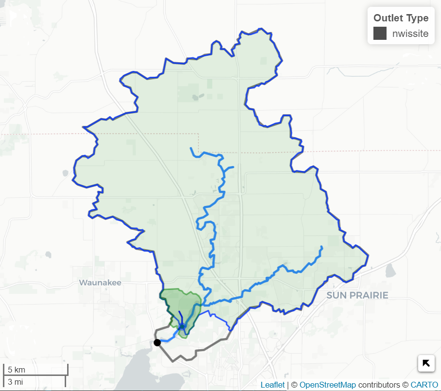
This figure is a zoomed out version of the one just above. It shows how we now have a custom delineated basin to this specific location.
Categories:
Keywords:
Related Posts
The Network Linked Data Index and geoconnex.us
May 14, 2021
The NLDI is a search engine that uses the river network as it’s index. Like a search engine, it can cache and index new data. Beyond indexing and data discovery, it also offers some convenient data services like basin boundaries and accumulated catchment characteristics.
NextGen WaterAlert is out!
October 18, 2022
Our team is pleased to announce that the transition from Legacy WaterAlert to NextGen WaterAlert is complete! Access NextGen WaterAlert now !
WaterAlert is a near real-time hydrologic alerting system. It can be used to set custom alerts to monitor stream, lake, and coastal conditions at USGS monitoring locations across the nation. NextGen WaterAlert is replacing a legacy version of WaterAlert which was first released in 2011. The NextGen version is the product of 12 months of user-centered design and development. Read more about the transition, feedback, and enhancements below.
WaterServices APIs will be decommissioned early 2027
January 7, 2026
We have released modernized Water Data APIs which will supersede the WaterServices family of APIs. WaterServices will be decommissioned in the first quarter of 2027. We will have more information about the decommission process, which may include intentional service degradation and blackouts, in the second half of 2026. We will not begin any intentional degradation of these services before August 2026.
Metadata in Water Data for the Nation
December 29, 2025
Introduction
Metadata are crucial to interpreting and understanding USGS water data. Metadata are data that provides information about other data. They provide important context to the water data you are viewing on WDFN pages or downloading from USGS Water Data APIs . USGS water data metadata includes codes and abbreviations, such as parameter codes, method codes, and observed properties.
Centralized Water Data in WDFN
December 23, 2025
Introduction
There have been a lot of changes to how you access USGS water data as we work to modernize data delivery in Water Data for the Nation (WDFN) and decommission NWISWeb. WDFN is no longer organizing data based on discipline specific landing pages (e.g., surface water, groundwater, water quality, and water use). WDFN also no longer provides a dedicated page displaying the data inventory or “summary of all available data” for each monitoring location as these features have been consolidated into modernized webpages. These changes will simplify our data delivery and enable all data collection categories to be found from the same pages and tools. This post will orient you to where to find the water data you need.