
WaterServices APIs will be decommissioned early 2027
We have released modernized Water Data APIs which will supersede the WaterServices family of APIs. Users will need to migrate their applications to use these new services in order to retain uninterrupted access to USGS water data going forward.
We have released modernized Water Data APIs which will supersede the WaterServices family of APIs. WaterServices will be decommissioned in the first quarter of 2027. We will have more information about the decommission process, which may include intentional service degradation and blackouts, in the second half of 2026. We will not begin any intentional degradation of these services before August 2026.
Users of WaterServices, and systems that access data from WaterServices such as the dataretrieval packages for R
and Python
, will need to migrate their existing applications before this time to retain uninterrupted access to USGS water data. You will need to migrate any code or applications that make any requests to https://waterservices.usgs.gov/
, any code that uses the readNWIS() family of functions in the R dataRetrieval package, or any code that uses the nwis module of the Python dataretrieval package.
WaterServices was the set of APIs hosted at waterservices.usgs.gov. These APIs made USGS water data available in machine-readable formats for programmers and applications to use and have provided the data underpinning a wide array of applications, including Water Data for the Nation, the National Water Dashboard, and dozens of applications developed by other Federal and state agencies as well as private organizations. After 15 years of continuous operations, WaterServices has now been superseded by a modernized API platform available at https://api.waterdata.usgs.gov/ogcapi/ .
These modernized APIs provide the same USGS water data users are accustomed to via an updated and more user-friendly interface. This interface provides a number of benefits, including GIS integration letting users access USGS data directly from their GIS platform of choice. However, this new interface will require updates to downstream applications.
To make this easier, we’ve developed extensive documentation for the new APIs, including both long-form documentation and OpenAPI-based reference documentation . We’ve additionally developed a migration guide which will help users move their applications from WaterServices to the new Water Data APIs.
Users of the R dataRetrieval package should update their code to use the new read_waterdata() functions available in the newest versions of the package on CRAN and GitHub. Multiple tutorials, including a vignette introducing the new functions
, a blog highlighting the new functions
, and detailed dataRetrieval documentation
are available to reference.
Users of the Python dataretrieval package should update their code to use the new waterdata module available in the newest versions of the package on PyPI and GitHub. We are currently developing additional documentation for working with this module.
These decommissions are happening as part of our broader modernization efforts, which include the modernization of a number of pages on NWISWeb. You can stay up to date with this modernization effort by subscribing to the Water Data for the Nation newsletter .
We understand that change is hard, and some of these changes might feel sudden. We’re here to help. We have staff ready to help you make the transition should you need it. Please reach out to us at gs-w_waterdata_support@usgs.gov with any questions.
Categories:
Keywords:
Related Posts
Big changes to USGS Water Data in 2025
May 28, 2025
Introduction
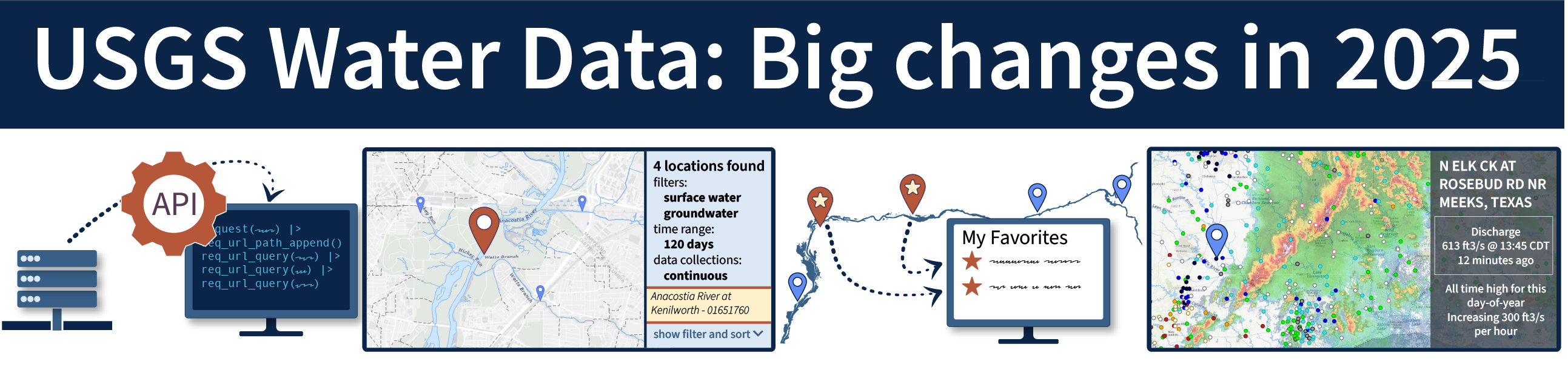
Some of the new features in WDFN for 2025, including API services, explore historical water data, create a list of your favorite monitoring locations, and view latest conditions and weather events.
Metadata in Water Data for the Nation
December 29, 2025
Introduction
Metadata are crucial to interpreting and understanding USGS water data. Metadata are data that provides information about other data. They provide important context to the water data you are viewing on WDFN pages or downloading from USGS Water Data APIs . USGS water data metadata includes codes and abbreviations, such as parameter codes, method codes, and observed properties.
Centralized Water Data in WDFN
December 23, 2025
Introduction
There have been a lot of changes to how you access USGS water data as we work to modernize data delivery in Water Data for the Nation (WDFN) and decommission NWISWeb. WDFN is no longer organizing data based on discipline specific landing pages (e.g., surface water, groundwater, water quality, and water use). WDFN also no longer provides a dedicated page displaying the data inventory or “summary of all available data” for each monitoring location as these features have been consolidated into modernized webpages. These changes will simplify our data delivery and enable all data collection categories to be found from the same pages and tools. This post will orient you to where to find the water data you need.
Daily data in Water Data for the Nation
November 21, 2025
There have been a lot of changes to how you access USGS water data as we work to modernize data delivery in WDFN and decommission NWISWeb. As we centralize and re-organize data delivery in WDFN, we have recently set out to describe different types of water data according to data collection categories . We started with re-organizing and expanding the data collection categories that are delivered on the Monitoring Location Page and are now working to deliver additional data collection categories on other WDFN pages as well. This blog is part of a series to help orient you to where you can find different types of data in WDFN pages and services. In this post, we want to focus on how you can access daily data in WDFN.
NWISWeb Decommission Campaign 2
November 21, 2025
This blog will share information on NWISWeb Decommission Campaign 2, the second in a set of three campaigns to decommission legacy NWISWeb pages currently hosted at https://waterdata.usgs.gov . Campaign 2 is expected to be ongoing from November 2025 through February 2026.